
On October 31, 2025, India Meteorological Department issued a dire warning: Bihar, Sub-Himalayan West Bengal, and Sikkim could see rainfall so intense it could trigger landslides, drown streets, and paralyze transport. The forecast, released at 2:30 p.m. IST on October 27, 2025, pinned the threat to a powerful depression over the east-central Arabian Sea and a well-marked low-pressure system over East Vidarbha — a combo that’s turning the eastern plains into a rain trap. Meanwhile, Delhi will barely get a damp sneeze — just a mild drizzle, if anything, with temperatures hovering just below seasonal norms.
What’s Coming Down — And How Much?
The IMD doesn’t mince words. Heavy rain? That’s 64.5 to 115.5 mm. Very heavy? 115.6 to 204.4 mm. But extremely heavy — the kind that turns roads into rivers and hillside villages into emergency zones — means more than 204.4 mm in 24 hours. That’s what’s predicted for isolated pockets in Sikkim and the foothills of West Bengal. In Patna, where the airport recorded 25°C on October 29 with no rain, the forecast for October 31 is anything but calm. Weather25.com estimates 3 to 8 rainy days in Bihar this month, with total rainfall hitting 97 mm — but the October 31 deluge could dump half that in a single day.
It’s not just numbers. It’s what happens when the sky opens. In Telangana, just days before, some areas soaked up over 30 cm of rain. Konkan and Goa weren’t far behind. Now, the rain band is shifting northeast. And here’s the twist: the IMD’s own models say forecast accuracy drops the further out you go. So while the October 31 warning is the most urgent, the preceding days — October 28 to 30 — could see building pressure, saturated soil, and rising rivers. A storm doesn’t arrive on the dot. It creeps in.
Why This Matters More Than Just Wet Streets
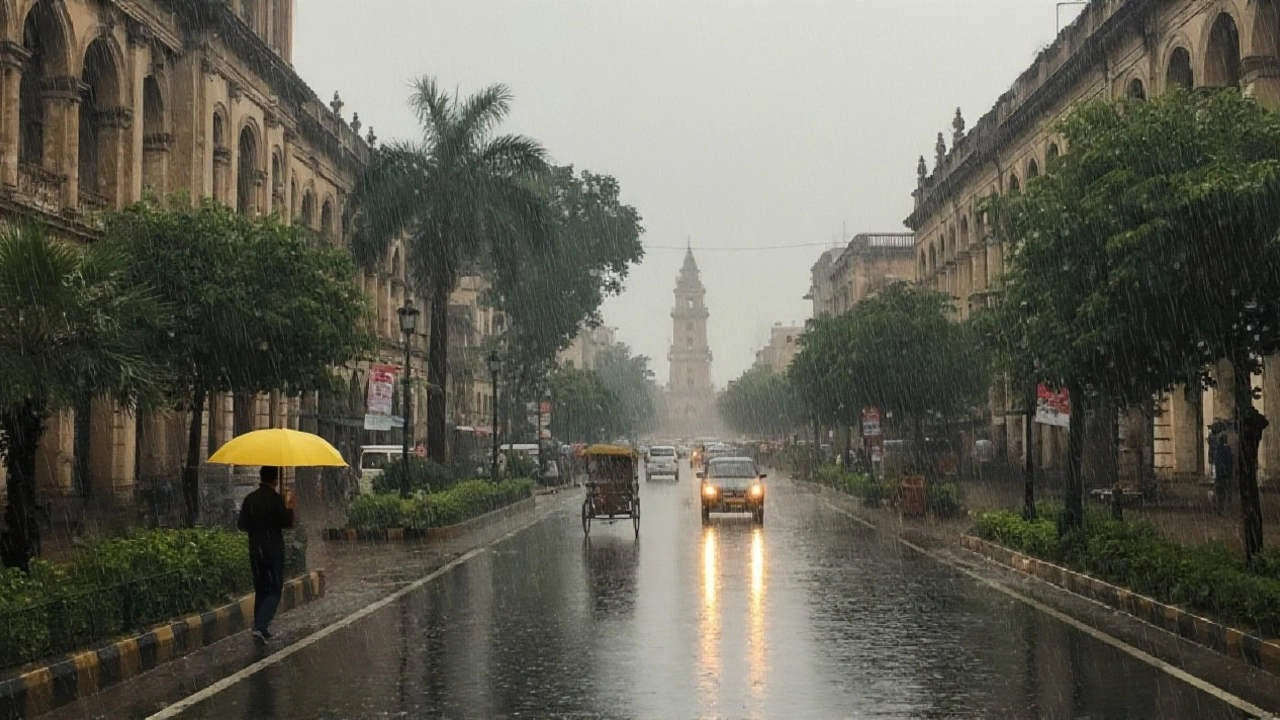
People in Bihar know this dance. Monsoon season is brutal, but October is supposed to be the calm before the winter chill. This isn’t monsoon. It’s an outlier — a late-season surge fueled by unusually warm Arabian Sea waters and a stalled low-pressure system that’s refusing to move. The result? Urban drainage systems, already strained from years of underinvestment, will buckle. In Patna, where roads flood after 20 mm of rain, 200+ mm is a disaster waiting to happen.
And it’s not just cities. The Sub-Himalayan belt — districts like Darjeeling, Jalpaiguri, and Kalimpong — are built on steep slopes with fragile soil. A single day of extreme rain can trigger dozens of landslides. In 2023, over 40 people died in Sikkim during a similar October event. The IMD’s orange and red alerts aren’t bureaucratic noise. They’re lifelines. Local authorities are being told to prepare: sandbagging, evacuating high-risk homes, clearing drains, and halting non-essential travel.
Delhi’s Mild Drizzle and the Paradox of Climate Patterns
While the east braces for flood watches, Delhi is getting a gentle mist. Maximum temperatures? 29–31°C — a full 1–2°C below normal. Minimums? 18–20°C, warmer than usual. The wind? Calm in the morning, a lazy southeast breeze in the afternoon. No thunderstorms. No flooding. Just a damp coat and a few soggy leaves.
But here’s the odd part: this isn’t normal. Delhi’s October weather is typically dry, sunny, and crisp. The fact that it’s seeing even light drizzle suggests a broader atmospheric shift — perhaps a lingering monsoon moisture trail or an unusual jet stream pattern. Experts aren’t calling it climate change outright, but they’re noting a trend: late-season rain events are becoming more erratic, more intense, and less predictable. What was once a 1-in-10-year anomaly is now a 1-in-4-year occurrence.
What’s Next? The Clock Is Ticking
October 31 is the deadline. But preparation can’t wait. The IMD’s district-wise warnings — available on their GIS portal — are being shared with district collectors, police, and disaster response teams. Schools in low-lying areas of Patna and Muzaffarpur are being told to prepare for closures. Railways are reviewing flood-prone routes between Malda and Katihar. The National Disaster Response Force has pre-positioned boats and rescue teams in Siliguri and Darjeeling.
For residents, it’s simple: stock water, avoid low-lying roads, check roof drains, and keep emergency numbers handy. The IMD’s message is blunt: “As the lead period increases, forecast accuracy decreases.” Translation? Don’t wait for the final warning. Act now.
Behind the Rain: A Pattern Repeating
This isn’t the first time eastern India has been blindsided by October rain. In 2021, Bihar saw 127 deaths from floods and landslides during an unseasonal downpour. In 2019, Sikkim’s road network collapsed after 180 mm fell in 12 hours. Climate scientists at the Indian Institute of Tropical Meteorology have linked these events to rising sea surface temperatures in the Arabian Sea — which have warmed by 0.7°C over the last three decades. Warmer water means more evaporation. More evaporation means more moisture in the air. More moisture, when stalled by weak winds, means extreme rainfall.
What’s new? The timing. Rain in October used to be a gentle farewell to monsoon. Now, it’s a violent encore. And with no major infrastructure upgrades in Bihar’s drainage systems since 2015, the gap between rainfall and resilience keeps widening.
Frequently Asked Questions
What does an orange or red alert mean for residents in Bihar and Sikkim?
An orange alert means heavy to very heavy rainfall is likely, and authorities should prepare for potential waterlogging and transport disruptions. A red alert means extremely heavy rainfall is expected — life-threatening conditions, including landslides and flash floods, are probable. Residents should avoid travel, stay away from riverbanks and slopes, and follow local evacuation orders immediately.
How does this rainfall compare to historical October patterns in Bihar?
Historically, Bihar receives about 50–70 mm of rain in October, spread over 2–3 days. This year’s forecast of up to 200+ mm in a single day on October 31 is nearly triple the monthly average. Events like this occurred only twice in the past 20 years — in 2019 and 2021 — both of which led to major relief operations and crop losses exceeding ₹1,200 crore.
Why is Delhi getting rain when other parts of North India are dry?
Delhi’s light drizzle is due to a lingering moisture plume from the Bay of Bengal that’s being drawn northwest by weak upper-level winds. While the main rain band is locked over Bihar and Sikkim, this moisture is just enough to trigger mist and very light showers in Delhi — not enough to cause flooding, but unusual enough to signal broader atmospheric instability.
What should people in hilly areas like Sikkim do immediately?
Residents in Sikkim’s hill towns should inspect slopes near homes for new cracks or water seepage, clear gutters and drainage channels, and avoid walking or driving on mountain roads after dark. Keep emergency kits ready — including flashlights, dry food, and first aid. Do not wait for official evacuation orders; if you see water rising fast or hear rumbling from hills, move to higher ground immediately.
Is this rainfall linked to climate change?
While no single event can be blamed solely on climate change, the frequency and intensity of extreme rainfall in October — a traditionally dry month — have increased significantly since 2010. Data from the Indian Meteorological Department shows a 35% rise in October rainfall extremes over the last 15 years, consistent with global warming trends that increase atmospheric moisture capacity.
How accurate is the IMD’s five-day forecast?
The IMD acknowledges that forecast accuracy declines beyond 72 hours. While the October 31 warning is based on strong model consensus, minor shifts in the low-pressure system’s path could change the exact areas hit hardest. That’s why they urge local authorities to act on the *potential* of extreme rain, not just the predicted numbers.